Category Archives: Announcements

Rugged Routes Releases Stoddard Wells, CA OHV GPS Map for Lowrance Off Road GPS

For Immediate Release

Rugged Routes Releases Stoddard Wells, CA OHV GPS Map for Lowrance Off Road GPS

High-Resolution, Color-Coded OHV Trails Map Provides Accurate Data for Off-Road Enthusiasts

Rancho Cucamonga, CA, 9/22/2023 — Rugged Routes, a leader in off-road mapping
solutions, announced the release of their Stoddard Wells, CA OHV map for Lowrance
GPS systems. Created by mapping veteran Steven Lutz, this cutting-edge product aims
to improve trail navigation for both casual and competitive off-road enthusiasts.
Steven Lutz, a trained Lowrance GPS mapping specialist with over a decade of
experience, has a rich history of 4-wheeling, dirt bike riding, and exploring the deserts of
California. “I personally needed better Lowrance off road GPS mapping to explore trails
and OHV areas that Iwasn’t familiar with. There’s a lack of proper signage and
documentation in Stoddard Wells. This gps map fills that void,” Lutz said.

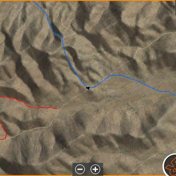
What sets this OHV GPS map apart are its high-resolution satellite imagery and colorcoded
trails, previously known only to local 4-wheel drive clubs, and are often not
documented in other mapping solutions. These unique features provide unprecedented
navigational accuracy, improving the off-road experience for users.
Installing the map is as simple as inserting an SD card into a compatible Lowrance off
road GPS unit and pressing an on-screen button to enable the satellite imagery layer. The map works 100% offline, requiring no subscriptions or additional downloads. “The interface is extremely logical and straightforward,” Lutz added. The map is designed for everyone from recreational UTV, 4×4, and desert truck
enthusiasts to competitive desert racers. The Stoddard Wells, CA OHV map is available
immediately and can be purchased at Rugged Routes’ website: RuggedRoutes.com. If a
customer needs assistance, responsive email support for simple questions is available as
well as the ability to schedule phone calls for more complex technical conversations.
There are also Lowrance GPS tutorials on the Rugged Routes YouTube channel at:
https://www.youtube.com/@RuggedRoutes?sub_confirmation=1
Steven Lutz revealed that additional GPS mapping and integration solutions are already
in development, with additional various product releases right around the corner. Those
interested in keeping up to date on Rugged Routes can can sign up for e-mail updates at:
http://list.ruggedrocks.com/?p=subscribe&id=2 or follow on Instagram at:
https://www.instagram.com/ruggedroutes/?hl=en
Final Thoughts
“This has been a long-awaited project. Mapping has a lot of momentum right now, so
users can expect additional announcements in the near future,” Lutz concluded.

Massive Lowrance Satellite GPS Maps – The ball is back in my court, Finally.

Lowrance and I have a habbit of playing Ping-Pong of sorts.  They do a system upgrade, I find a way to maximize the capability, in which case they do a system upgrade, and I find a way to maximize the capability. Behind the scenes this has happened many times in my journey to bring various devices to the off road industry. I do realize that from the outside, it doesn’t seem like i’ve gotten much done but behind the scnes, I’ll make your head spin.

For many years the Lowrance systems have had support for a maximum SD card card size of 32GB. and before that there was once a 2GB limit. 10 years ago the 32GB limit was great, but times have changed. It’s put me in a situation where if I were to go through the grueling process of making a large map beyond that limit, It woldn’t be supported. However, There was a recent software update to HDS Carbon, Live, and Pro as well as Elite FS that now seems to be (exact details to be verified) support SD Cards of atleast 256GB.  Being the techy nerd that I am and what I know about this type of technology, the support implemented for 256GB should grow with technology for a long time to come. Latest sd card sizes becoming available right now are up to 1TB! My sd card supplier has a 1TB sample card on the way. I level up and make larger gps maps, one of the servers that I use for processing map data is getting a significant hard drive upgrade which are being onboarded as I write this. The first goal will be to cram imagery of the entire state of AZ on one card. With a few clever computer tricks, math and magic, I should be able to get this done.

However, there is one more big question. The trail data on top of the Imagery.
I need feedback from you. I’ve gotten feedback about how awsome my high detail gps maps are, however, they are very time consuming and a ton of work… very frustrating at times. It would be unreasonable to expect that same type of attention to detail for every road / trail in the state or country.
My question is, is that ok? Have I been going overboard on my other offerings? Clearly I can’t run every road in the state myself but I can do some basic edits and correction to official data. Some guidance would be much appreciated. Ultiamtely I need to produce something that is worth my time but also is something that makes my customers happy.

Please drop of feedback in the comments below.

Thank you
-Steven Lutz


US Forest Service Lowrance GPS Topo Maps – Now Available

Want to get outdoors but need to beat the desert heat? Head to the forest!
United States Forest Service FSTopo maps are 1:2400 scale maps with coverage foreset service areas and is available on a state by state basis for the central and western states.
Compatilbe with HDS (Gen2 and Newer) and Elite (Ti & FS) series GPS Units.

Maps Include:
-Roads & Highways
-Forest Service Roads & Trails
-Hiking Trails
-Elevation Contours / Topo Lines
-Forest Boundaries
-Campgrounds / Campsites
-And more…

To buy now, visit: https://ruggedroutes.com/National-Forest-FSTopo-Maps-Lowrance-GPS-Units.html
Or
Check out the intro video below for more info:
https://www.youtube.com/watch?v=SFe2UY0_FnM